research projects


research projects

The Canadian Shield consists of a number of Archean cratonic fragments sutured by Proterozoic collisional belts. How did these ancient cratonic fragments originate, and do we see evidence that tectonic processes similar to modern plate tectonics existed during their creation? The best studied of these cratonic fragments, the Superior province, is subdivided into long, curvilinear belts based on the relative abundances of volcanic and plutonic versus metasedimentary rocks. This belt-like structure of litho-tectonic assemblages was interpreted to signify that the Superior craton grew by the addition of successively younger, allochthonous island arc, oceanic, and forearc sedimentary terranes, punctuated by mantle plume events (e.g., Kimura et al., 1993; Langford and Morin, 1976; Thurston, 1991), supporting a plate tectonic model for Archean crustal growth that is similar to modern plate tectonics. However, geological studies over the past decade suggest that litho-tectonic assemblages may commonly be autochthonous in origin (as summarized in Thurston, 2002).
Critical to models of the evolution of the Superior (and other) craton are the field relationships and geochemistry of volcanic, plutonic, and sedimentary rocks in greenstone belts that retain a record of their tectonic setting. Based on the geochemical characteristics of modern volcanic rocks in different plate tectonic settings, the geochemical signatures of ancient volcanic rocks have been used to distinguish between continental, oceanic (spreading centre, oceanic plateau, seamount), back-arc, or volcanic arc origins for greenstone belts in Canada and world-wide (e.g., Condie and Baragar, 1974).
The geology of the Slave province contrasts strongly with that of the Superior province. It lacks the belt-like structure of the Superior, is dominated by metasedimentary and plutonic rocks, includes only a small volume of volcanic greenstone belts, and includes three to four rifted margins (Bleeker, 2003; Padgham and Fyson, 1992). Thus the origin and evolution of the Slave province appears to be dramatically different from that of the Superior province. The small volume of volcanic greenstone belts limits the extent to which we can use the geochemistry of volcanic rocks to infer tectonic setting(s) craton-wide, but also enhances the importance of such studies to understanding the evolution of the Slave.
The Yellowknife Volcanic Belt (YVB) is one of several small greenstone belts exposed in the southern part of the Slave Province. This greenstone belt is extremely well preserved, has well-exposed contact relationships, and has suffered primarily low-grade, greenschist facies metamorphism. The YVB has been mapped in considerable detail, has been the subject of major and trace element geochemical studies, and is well dated by modern U-Pb zircon techniques. Nevertheless, only a handful of modern rare earth element and neodymium (Nd) isotopic analyses exist for volcanic and plutonic rocks in the Yellowknife area (e.g., Davis and Hegner, 1992; Dudás, 1989; Yamashita and Creaser, 1999). Radiogenic isotopic data, in conjunction with field observations, major and trace element geochemistry, have the potential to help resolve stratigraphic and tectonic problems, and to distinguish between different tectonic scenarios for the origin of the volcanic rocks.
This geochemical study began in 1996, soon after the completion of the first U-Pb zircon geochronological study of the YVB and the recognition that the volcanic sequence was underlain by older continental crust (Isachsen, 1992; Isachsen and Bowring, 1997; Isachsen et al., 1991; MacLachlan and Helmstaedt, 1993). Several geologic problems were identified that could be addressed by a detailed geochemical study. First, what is the geological relationship between the 2.7 Ga Kam and 2.66 Ga Banting Groups of the YVB, and what tectonic setting is inferred from their geochemical systematics? Second, within the Kam Group, what magmatic evolution trends can be identified from the base of the volcanic pile to its top and what processes are responsible? Does older basement play a role? Third, within the poorly studied Banting Group, are putative Banting rocks exposed along the western shore of Yellowknife Bay really part of the Banting Group? Are felsic dykes that cut the Kam Group feeders to the Banting Group (Helmstaedt and Padgham, 1986; Isachsen, 1992)? What geochemical similarities exist between the Banting Group and some other 2.66 Ga volcanic complexes in the southwestern Slave Province? Fourth, are other small greenstone belts within the immediate Yellowknife area related to YVB volcanism?
In collaboration with Luke Ootes at the NT Geoscience Office and Jan Peter at the GSC Ottawa, we are starting a new project in 2012 looking at the petrology and VMS potential of “Banting-age” rocks in the southern Slave Province. Initially we are zeroing in on the southern Beaulieu-Cameron belt east of Yellowknife and on the Indin Lake greenstone belt northwest of Yellowknife. Prospective areas include regions with poor outcrop but abundant drill core resources to do 3-D geological reconstructions and geochemical studies, as well as areas with excellent outcrop where fires have removed lichen cover.
SUMMARY – NEW KNOWLEDGE CONCERNING BEDROCK GEOCHEMISTRY AND GEOLOGICAL SETTINGS
Prior to this series of studies, the geology, primary rock types, general geochronological sequence, and major element characteristics of the Yellowknife greenstone belt had been outlined, and several models for the origin of the belt were proposed. A summary of the geochemical characteristics of all of the areas discussed in this paper is shown in Table 2.
In particular, the basic petrologic differences between the Kam and Banting Groups were known prior to this work but their relationship was uncertain. At the time that this work began, a ‘backarc-arc’ pair relationship was the model to test, as was the ‘autochthonous – allochthonous’ relationship between the greenstone belt and surrounding rocks. It is clear that the Kam Group represents a large outpouring of primarily mafic magmas within a submarine, rift environment. However, the setting of this rift is confined by the presence of inherited zircons in tuffaceous units and Nd isotope ratios that decrease with increasing magma evolution from basalt to rhyolite, which demand the presence of older continental basement beneath the belt. Interaction between upper mantle melts and basement rocks is recorded in volcanic rocks throughout the 10 km-thick volcanic package. In turn, these isotopic characteristics (combined with field mapping and U-Pb geochronology of Bleeker et al., 1999b.; Bleeker et al., 1999a; MacLachlan, 1993; MacLachlan and Helmstaedt, 1995) show that Kam Group magmas were emplaced through and upon existing Central Slave basement, leaving little doubt that the YVB is autochthonous.
We have shown that the ‘calc-alkaline’ label attached to the Banting Group is a red herring: mafic rocks follow a tholeiitic fractionation trend, similar to the Kam Group, whereas felsic rocks are melts of juvenile mafic crust and are unrelated directly to the mafic rocks. The contact between the Banting and Kam groups is everywhere unconformable, including the Giant Section where a transitional sequence of rocks was proposed previously. The #9 feldspar porphyry dykes that cut the Kam Group are identical chemically to felsic rocks of the Banting Group, and a large number of these dykes radiate from the Ryan Lake Pluton that also has a Banting geochemical signature and age (Ootes et al., 2002). Putative Banting –like rocks exposed along the west shores of Yellowknife Bay and beneath central Yellowknife Bay are indeed southern equivalents of the Ingraham Formation of the Banting Group.
The geochemistry of felsic rocks in the Banting Group can be explained by either a subduction or crustal melting model, which utilize similar source rocks (subducted oceanic crust vs. mafic lower crust) but in very different tectonic settings. What other evidence is there to support either model? The convergent margin models assumes that plate subduction occurred during the Archean as it does today. In the convergent margin model, it would be expected that mafic rocks interbedded with the felsic lavas would have a subduction zone signature, but instead Shot Lake pillow basalts have a depleted mantle source with no subduction signature at all. Unlike modern arcs, the Banting Group and other 2.66 Ga felsic complexes in the Slave province are not large-scale linear magmatic systems with associated metasedimentary accretionary prisms, subvolcanic plutonic belts, and evidence for crustal uplift due to plate collision. It is also remarkable that ALL Banting felsic rocks have an adakite composition, unlike modern arcs where adakites are relatively rare, but the small size of the Banting Group and a higher Archean geothermal gradient to promote slab melting may explain this. Thus, there is little geological evidence to support an arc origin for 2.66 Ga magmatic rocks in the Slave province. Instead, 2.66 Ga felsic complexes are sprinkled across the southwestern Slave Province and may be the product of a widespread tectonothermal event in this part of the Slave Province. Mafic lavas in the Banting Group are submarine pillow lavas, and the Banting Group and its equivalents are associated with thick metasedimentary units (e.g., Burwash Formation turbidites), consistent with an extensional setting that might arise due to crustal thinning, heating and melting. Our reconnaissance studies of the Clan Lake and Russell Lake-Snare River complexes show that they too have Banting-like geochemical and isotopic characteristics. Further study of 2.66 Ga felsic volcanism throughout the southern Slave province (e.g., southern Cameron-Beaulieu belt) is required to further establish this crustal melting event hypothesis, as is a geochemical study of the Western Granodiorite Complex to find plutonic equivalents of the Banting Group besides the Ryan Lake Pluton.
One as yet unresolved question is the exact depositional relationship between the Banting and Kam Groups. Was the Banting Group deposited unconformably over the Kam Group in its present geographic position? The occurrence of the #9 dykes cutting the Kam Group below the Kam-Banting contact is evidence that the two rock groups have always occupied their current relative geographic position. However, the dykes cannot be seen to cross the contact. In addition, our data from Clan Lake and Russell Lake/Snare River complexes show that other Banting-like volcanic complexes exist in close proximity to the main YVB, and potentially the #9 dykes may have fed the Clan Lake (or some other?) felsic volcanic centre. Unfortunately, the #9 dyke – Banting Group relationship cannot give us unequivocal information concerning motion along the Yellowknife River Fault Zone.
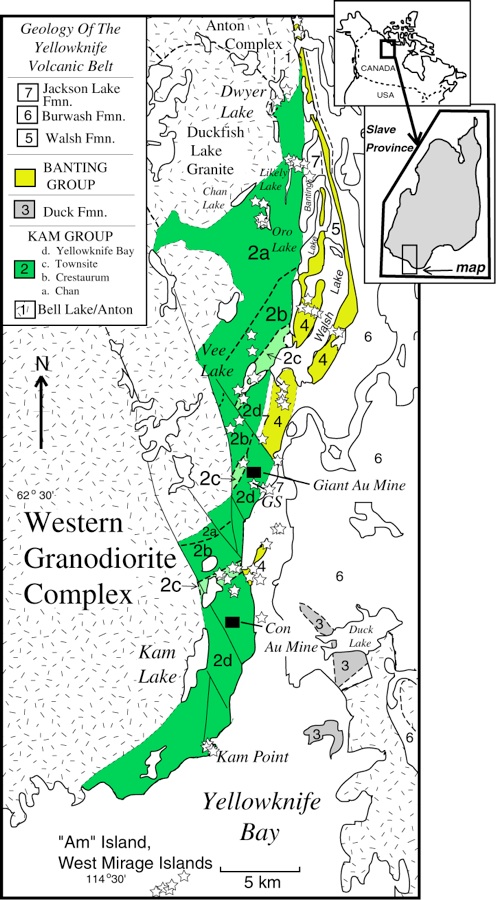
This map of the Yellowknife Greenstone belt shows most of our sample localities.
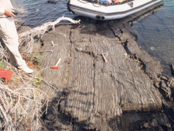
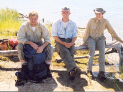
Photos: Top: Banded iron formation at Bell Lake, just north of the Yellowknife belt. Bottom left: Collaborators Wulf Mueller, Hendrik Falck, and Patricia Corcoran at Clan Lake. All photos by B. Cousens.
Papers:
Kam Group Kampaper.pdf (Journal of Geology)
Banting Group Banting.pdf (Canadian Journal of Earth Sciences)
EXTECH Volume Bedrock Geochemistry Chapter9.pdf
EXTECH Volume Gold Mineralization and Pb Isotopes Chapter24.pdf
Yellowknife Greenstone Belt, Northwest Territories
1996-present